|
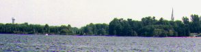
The Arnprior area of the Ottawa River
|
 The approach to Arnprior.
 |
The waters above the Chats Falls hydro electric dam often appear to be
forbidden territory for most people who sail the lower part of the Ottawa River
which includes Lake Deschenes. However, this body of water is forbidden
territory only for those people who are unable to trailer or transport their
boats around the dam. Since our family has a highly trailerable Macgregor 25,
we decided to explore these cruising grounds. Here is what we discovered.
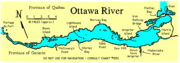
Differences Above & Below the Dam
Although there are inevitable similarities between the parts of the Ottawa
River above and below the Chats Falls dam, there are also some important
differences. We noticed that cruising and overnight anchoring does not seem to
be very popular on the waters above the dam. In fact, we soon realized that
this was power boat country. It's not that people are into mega horsepower,
it's just that sailing has never caught on in a big way. During our cruise, we
could see sailboats here and there, but they were few and far between. The ones
we did see tended to be dinghies or trailerable sailboats in the 20 to 25 foot
range.
The actual body of water is a little smaller than what people are used to
below the Chats Falls Dam. While this part of the Ottawa River is approximately
38 kilometers (23 miles) long, only 26 kilometers (16 miles) of it would be of
much interest to anyone cruising with a sailboat. It also has quite a few
shallow spots, especially in some areas along the Quebec side of the river that
are littered with small islands. Shoals in these areas tend to spoil what might
otherwise be very interesting anchorages. Whatever the case, it is still easy
to navigate the main channel of the river with the aid of Canadian
hydrographical chart #1551.
As we started our cruise, we made a number of other observation about this
part of the Ottawa River. We found that there are no Gatineau Hills to dominate
the view of the Quebec side of the river. We were surprised to see that, mile
for mile, the shoreline of this body of water has as many cottages and built-up
areas as the part of the river that we are familiar with. And we noted that,
unfortunately, navigable access to and from this body of water is cut off by
the Chats Falls Dam in the east, and the Chenaux dam at Portage-du-Fort in the
west. On this last point, it is worth mentioning that by the summer of 2004 a
special hydraulic trailer service operated by Lake Temiskaming/Ottawa River
Waterway Project should be in place, and it will allow boats to bypass the
Chenaux dam.
Starting off from the Madawaska River
Like many people visiting this body of water, we began our cruise in Arnprior at one of several launch ramps located in and around the mouth of the
Madawaska River. Arnprior Island was the first thing we noticed when heading
out into the Ottawa River. Local boaters told us there are shoals roughly
midway between this island and the Ontario shoreline which are somewhat more
dangerous than the chart would suggest. Luckily, they are easily avoided by
staying on east of a line drawn between the mouth of the Madawaska River and
Arnprior Island.
We first headed east and quickly spotted the iron railway bridge which
crosses the river further downstream. Clearance under this bridge is limited to
15 feet, meaning that larger sailboats will not be able to travel the final 3
kilometers (2 miles) of the river lying above the Chats Falls Dam. However,
there is little reason to do so. The chart indicates that the area is peppered
with shoals and there are reports that the current on this part of the river
can be quite strong if the dam is spilling large amounts of water.
There is an anchorage in the northwest corner of Chats Bay, on the Quebec
side of the river just opposite of Arnprior. It is not a spectacular anchorage
in terms of view or privacy, but it has a good mud bottom and offers excellent
protection from a wide range of winds, including the area's prevailing
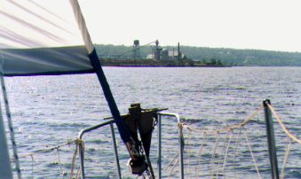 The Gillies Saw
Mill.
The Gillies Saw
Mill. |
northwest wind. The main draw back to this anchorage is that it is within
earshot of numerous cottages, although we did find a couple of spots where it
was possible to drop the hook without being immediately in front of someone's
residences. Once we settled in for the night, we also discovered that this
anchorage is in easy earshot of a railway line that runs behind the cottages.
Heading up river means passing relatively close to the south side of
Arnprior Island in order to avoid the shoals mentioned earlier. The Gillies Saw
Mill is the next major feature of this body of water, and its tall stacks of
timber dominate the scenery for several hundred feet of shoreline. When a west
wind is blowing, the scent of freshly cut wood is enough to convince boaters
that they are sailing through the middle of a lumber yard, which is almost the
case.
Norway Bay: "Little Ottawa"
Once past the saw mill, Norway Bay quickly comes into view on the Quebec
side of the river. The Chart indicates that the village of Norway Bay has a
public pier which jets out some 600 hundred feet into the Ottawa River. Sand
Point is located on the opposite side of the river from Norway Bay, and it has
a wharf with a public launch ramp.
Because of the pier and relatively large size of this village, we figured
Norway Bay would be a good place to stop to replenish our ice supplies and
check things out. Unfortunately, this community does not go out of its way to
make boaters feel welcome. Its east side is cordoned off for swimmers,
while the rest of the pier has been stripped of cleats and any other appendages
to tie up to. The west side of the pier has a ladder leading down to a 5 by 3
foot landing for a boat, but it too is lacking any place to tie a line to. We
managed to tie our dock lines to the ladder, but this was not a satisfactory
arrangement as the boat kept pivoting around the small landing.
(Update: It appears that Norway Bay has taken steps to make boaters feel more welcome. There are reports that the community has installed new docking facilities on the west side of the pier to answer the needs of boaters. Information provided in spring of 1997.)
The village of Norway Bay is apparently known as "Little Ottawa", and
largely consists of rows upon rows of cottages, many of which sit on tiny lots
and are equipped with satellite dishes. A ten minute walk up the road leading
to the pier brought me to a convenience store where it was possible to stock up
on ice and other supplies. However, I found myself waiting at the cash because
of a lineup of people waiting to return and sign out video movies.
We didn't spend much time at Norway Bay, and we were soon
heading up river. In order to avoid some shoals in the area west of Norway Bay,
our route took us around the south side of Lighthouse Island. As we passed the
island, we noticed that despite its name and what the current chart indicates,
it no longer has a lighthouse! We could not tell if it is inhabited, but we did
notice that its northwest side consists of a rock facade which drops almost
vertically into relatively deep water. This should make it possible for boats
to tie up right against the island, and we saw at least one powerboat doing
this.
Anchorage Behind Boom Island?
Continuing further up river involves navigating through a shallow area
just south of the Kennedy Islands, but this is fairly easy with the aid of
strategically placed buoys. Beyond this lies Boom Island. Sailors in the
Arnprior area report that there is an anchorage in the narrow strip of water
between the island and the Quebec shoreline. Immediately to the east of Boom
Island are two slightly smaller islands which are unnamed on the chart. Care
should be taken not to drop the hook in what first appears to be an ideal
anchorage behind one of these island. Although there is sufficient depth, a
close inspection of the chart will reveal that this spot has a fouled bottom and
is not suitable for anchoring.
We wanted to check out the anchorage behind Boom Island. We noticed a
rather nasty looking rock (charted and buoyed with plastic bottles) guarding
the southeast entrance of this channel between Boom Island and the unnamed
islands. As we slowly motored into this area, we also spotted some other
rocks/deadheads further in. At the time a fairly strong west wind and
associated wave action was pushing us into this restricted channel faster than
we wanted. We therefore decided to back out and come back later in our cruise
to check out this anchorage under more favourable conditions.
It was hot and our kids were in need of a swim stop, so we crossed to the
Ontario side of the river and dropped anchor behind McCrearys Point. This land
formation appears to have been created by deposits flowing from the Bonnechere
River. The point offers good protection from west to south winds, but not much
else. It is also exposed to the wake of passing powerboats, and its shoreline
is surrounded by cottages and houses. It was fine for a swim stop, but we were
soon heading down river looking for a suitable overnight anchorage.
Stories of an Anchorage at Stories Bay
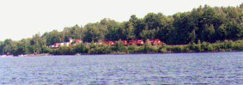 The train passing by the anchorage at Stories Bay.
 |
We had our eyes set on Stories Bay on the Ontario side of the river
southwest of Lighthouse Island. As we made our way into the bottom corner of
this bay, we discovered a beautiful anchorage surrounded by an undeveloped
shoreline. It is well sheltered from winds blowing west and south, and by
tucking our boat in behind a prominent rock outcrop, we also assured ourselves
full protection from any north wind. The bay has plenty of room for two or
three boats, and its mud bottom makes for easy anchoring. Generally, it is
deeper and offers more protection than the chart would suggest.
The only down side to this anchorage is that there is a railway line
running right next to Stories Bay. If I recall correctly, my kids counted one
train with four locomotives pulling a hundred and two cars. Mercifully, the
trains do not have to blast their horns because of nearby road crossings.
Unfortunately, our cruise was cut short by inclement weather, and Stories
Bay was our last anchorage on this part of the Ottawa River. We had planned to
spend another day or two exploring this body of water, and obviously wanted to
check out the anchorage behind Boom Island.
We were even thinking of poking our nose into the final seven kilometers
(four miles) of the river leading up to the Chenaux dam. We probably would not
have gone very far in this direction as the chart indicates that this stretch
of the Ottawa River is very narrow, and that parts of it are stuffed with small
islands and sand bars. The width of the resulting waterways range from several
hundred feet to not much more than a thousand feet. One powerboater (and former
sailor) familiar with the area believes that when the water is running fast,
sailboats equipped the standard 9.9 horsepower outboard could have a very
difficult time handling the currents in this part of the river.
Although our stay on this body of water was cut short, we saw enough of it
to know that it can accommodate boats setting out on a three or four day
cruise. There can be little doubt that people used to sailing below the Chats
Falls dam will soon feel right at home on this part of the Ottawa River.
At highway speeds, Arnprior is only a 30 minute drive from the Lac Deschenes area in west-end Ottawa.
Turn off onto the Madawaska Road when approaching the town from the east on Highway 17. In a few kilometers you will come to a bridge that crosses the
Madawaska River. Downtown Arnprior begins on the other side of the bridge, but
if you want to go to the Chats Lakes Yacht Club, you will
have to turn right on the first street before the bridge (appropriately named
Bridge Street). You will then have to turn left onto Riverview Drive, on which
you find the club. This is a residential area so it is
fairly easy to find your way around.
The Chats Lakes Yacht Club does not offer
services to the general public, but it often gives permission to members
of other yacht clubs to use its facilities. Finding someone to ask permission
could be a problem on weekdays when there may not be many people around this
small club. I should add that I was made to feel very welcomed when using their
facilities to launch and retrieve our boat. The club has a concrete ramp that
is more or less in the same condition as the one at the marina. It is slightly
steeper than normal.
On the other side of the Madawaska River is the HMCS Marina (behind the Catholic Church in the heart of town).
This marina has a 100 slips and a full service launch ramp. It also operates the Fitzroy Ottawa River Bypass and can haul a variety of boats.
To get there, you will have to cross the bridge into the beginnings of downtown
Arnprior. You then turn right on the first street after the bridge (there is a
small museum at the corner). The phone number for the marina is 613-623-5400.
One last word about launching and retrieving boats on the Madawaska River
in Arnprior. There is a weir (a long mini dam) a little way upriver on the
Madawaska. It is in easy view of the yacht club and marina. Quite a strong current will develop in the Madawaska
River when the generating station further upstream causes water to spill over
the lip of the weir. Local boaters say this can make launching and retrieving a
boat very difficult, though not impossible.
Text, photos, and map by Michael McGoldrick.
(article first written in 1995, with a few minor updates)
[ Copyright & Disclaimer ]
[ Return to Home Page ]
[ Sailquest.com ]
|