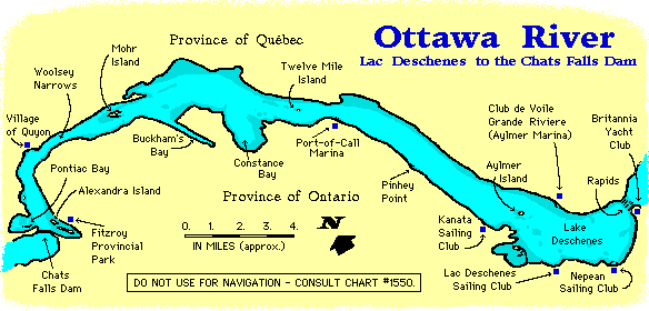
Cruising Guide to the Ottawa River
Lake Deschenes to the Chats Falls Dam
|
Note that this cruising
guide contains essentially the same the information
provided in the Virtual Cruise.
However,
it is present in format that is more suitable for printing out a hard copy.
By Michael McGoldrick
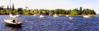
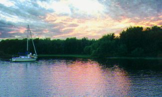
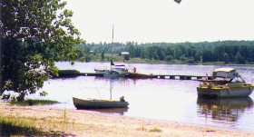
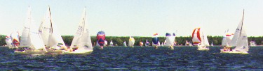 Racing on Lake Deschenes. It can get crowded.
 |
The largest sailing community in the national capital region is trapped
within a 27 mile segment of the Ottawa River, but people have learned to make
the best with what they have. In fact, they have turned this stretch of water
into a self-contained microcosm of the larger sailing world.
This part of the Ottawa River begins with Lake Deschenes in the City
of Ottawa's west-end, and it continues up river to the Chat Falls hydro
electric dam near the small town of Fitzroy Harbour. It includes a
number of well equipped and surprisingly large marina facilities,
several strategically placed overnight anchorages, various racing fleets,
and over a thousand sailboats, many of which are in the 25 to 35 foot
range.
It is unfortunate that a series of rapids in the east, and the dam to the
west, isolates this part of the river from any other navigable waters. The
rapids are particularly frustrating as they cut off what would otherwise be
convenient waterway access to and from Lake Ontario via the Rideau Canal
system. At the western end, a hydro-electric dam and other barriers stand in
the way of the centuries old dream of establishing a navigable waterway
connecting the Ottawa River to the Georgian Bay.
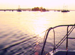
 Boats pass
each other on Lac Deschênes.
Boats pass
each other on Lac Deschênes. |
Such limitations mean that Ottawa sailors have become adept at
overcoming obstacles preventing access to and from the river. Trailer-sailing
is popular for obvious reasons, and this is especially true for those who are
anxious to find new competition on various racing circuits. Owners of some of
the larger vessels (30 & 32 footers) have resorted to a regular routine of
transporting their sailboats
to Lake Ontario or Georgian Bay for one or two months every summer. Moreover, those
catering to the local nautical trade say that the Ottawa area has more than its
share of sailboats that have made it to the Caribbean and beyond.
Whatever the case, the majority of area sailors stay put on the Ottawa
River and gladly make the best of what they have. Nothing illustrates this
better than the various sailing and yacht clubs which have popped up around
Lake Deschenes. These include the Lac Deschenes Sailing Club and Kanata Sailing
Club. Both have loyal followings and tend to concentrate on providing services
for dinghies and other small boats. The Club de Voile Grande Riviere can be
found at the Aylmer Marina on the Quebec side of the river. It has top notch
facilities which can accommodate boats well over 30 feet in length.
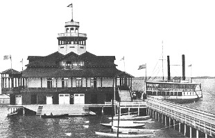
The Britannia Yacht Club is the oldest and best known club on this part of
the Ottawa River. It was established in 1887, and it opened its first clubhouse
in 1896 in what was then the middle of Ottawa's summer cottage district.
Britannia's yacht basin traces its origins to excavation work from
 BYC's old clubhouse which was destoryed by fire in 1918.
 |
an abandoned
turn-of-the-century project to harness power from the fast moving waters of
the Deschenes Rapids. By comparison, the establishment of the Nepean Sailing
Club is a relatively recent development. in 1980, the current site
of the Nepean Sailing Club was nothing more than a thin strip of neglected land
between Carling Avenue and a shallow corner of Lake Deschenes. The breakwater,
boat compound, and park land which surround the NSC clubhouse are all new and
were put in place with landfill. The result is a a club which compares
favourably with any other in North America.
Efforts to enhance the sailing and cruising potential of the Ottawa River go beyond the
various clubs that have sprung up around Lake Deschenes. In order to open up
some new and very interesting anchorages, a group of sailors banded together to
mark the tortuous channel into Pontiac Bay with over 30 private buoys. They
even installed a number of mooring buoys in areas of the bay with poor holding
ground. All this was quite a feat considering that the work was carried out by
volunteers, and that some of the buoys are held in place with 350 pound
weights.
Visitors to area and local trailer sailors will be glad to know that there
are good launch ramps open to the public (for a fee) at the Nepean Sailing Club,
the Aylmer Marina, and the Port-of-Call Marina. Public ramps exist at Buckham's Bay,
Quyon, and Fitzroy Harbour towards the western end of this body of water, and
there is always the possibility of finding other facilities, including
naturally occurring ramps at the end of public roadways (for light-weight
boats).
Departing from Lac Deschenes
The departure point for a cruise upriver will probably be one of the three
larger marina/yacht club facilities found on Lake Deschenes, and Mohr Island or
Pontiac Bay will likely be the destination.
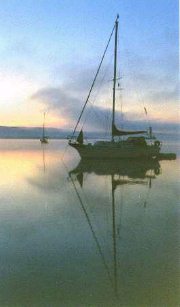
 Leaving the Aylmer
Island anchorage at the end
Leaving the Aylmer
Island anchorage at the end
of a hot sunny day. |
Before departing, sailors new to the area should note that the prevailing wind
for this part of the river is from the west to northwest, meaning anyone
sailing up river will probably be working against the wind at least some of the
time. Fortunately, the current in this part of the Ottawa River is rarely
noticeable (except for people who into serious racing), and water quality
is easily good enough for swimming. There are a number of shoals in Lake
Deschenes and around Constance Bay, but with a little caution, boats drawing
up to 5 feet should not have too much trouble in this body of water. The
entire area is covered by Canadian hydrographic chart # 1550.
Aylmer Island will generally be the first heading for boats sailing up river.
It is a rather nice little island which comes complete with a beach
and small lighthouse. There is something of a spectacular up-river view
from the top of the small hill on its northwest side. But anyone romping
around on this island should be very careful to avoid the poison ivy by staying on the foot paths and maneuvering around the underbrush
(and there can be a lot of poison ivy).
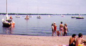
The area south-east of the island is used as a day anchorage, and it
is very popular with sailors who wish to stop for a swim on those hot windless
afternoons. In fact, an instant community of several dozen boats can suddenly
pop up in this area, with many rafted together, as their crews
take a break to swim, gam, barbeque, and generally enjoy the summer life.
Moreover, the small beach on the south-east corner of the island can
be put to good use by sailors who are somehow overcome by the urge to leave their boats and go ashore.
 Looking out from the beach on Aylmer Island.
 |
Aylmer Island is also a great place to anchor for the afternoon because it provides
people with a front row seat to all the traffic heading upriver or back into Lac
Deschenes, and its seems sailors will always spot someone they know. Boats tend to
drop anchor in the area between the Island and buoy K-9, but unless it is going
to be dead calm, Aylmer is not regarded as a good overnight anchorage.
It is interesting to note that Aylmer Island is an old Indian burial
ground. A mass grave site was discovered in the early 1900's when the foundation
for a lighthouse was being dug. Several individual Algonquin grave sites
have also been found on the island.
Continuing up river will mean passing on the north side of Aylmer Island
in order to avoid the shoals found on its south-west side. In a little over six
kilometres (four miles) Pinhey Point will come into view on the Ontario side of
the river.
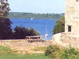
Pinhey Point (& Local Heritage Site)
Pinhey Point provides for a pretty little bay which serves as a very
popular day anchorage, and a convenient overnight anchorage. Because
of its proximity to the marinas and sailing clubs on Lake
Deschenes, it can be very busy. This is especially true on Friday
evenings when boats pour into Pinhey Point in order to get an early
start for a weekend cruise upriver.
 Pinhey Point anchorage ( the actual point is on the right ).
 |
Although the area behind the point offers protection from a wide variety
of winds, a large number of boats regularly anchor along the shoreline
up to a half kilometer downriver from Pinhey Point. These boats will
be protected from winds from the south to the west, including the
prevailing northwest winds. However, if the winds shift a little more to
the north, the waves will start to refract around the point, and these
boats may spend a bumpy night at anchor.
While Pinhey Point can fill up quite fast on weekends, it is worth noting
that boats arriving in the evening hours still have a chance of finding a nice
spot to anchor for the night. This is because many people use Pinhey Point
as a day anchorage, and after they are finished supper, they pull up
anchor and head home. (Most sailboats can motor back to one of the clubs on the far
side of Lake Deschenes in slightly under two hours. Sailing times will,
of course, depend on the wind conditions.)
Pinhey Point has a muddy bottom, but it is littered with old logs that
have long lost their buoyancy. Although efforts have been made to clean up
these old logs, those that remain can still make anchoring difficult on
occasion.
Onshore, Pinhey Point is home to an 88 acre heritage site. Hamnett Pinhey was
an English ship owner who came to Canada in 1820. He was granted a thousand
acres on the Ottawa River for his services to the King as blockade runner
during the Napoleonic wars. He quickly transformed this land into an estate
which he called Horaceville, after his eldest son. At one time it included a
mill, a church, a store, barns, and a manor house.
 The
Greek Isles? No - a view from Pinhey Pt. onshore.
The
Greek Isles? No - a view from Pinhey Pt. onshore. |
The manor house has survived in relatively good condition and is open
for tours from Wednesday to Sunday throughout the summer months. The rest of
the time people are free to roam around the grounds of the heritage site where
they will find picnic tables, public toilets (outhouses), a children's play
structure, and a bandstand which has been erected by the City of Kanata.
The Pinhey's Point Foundation organizes events and historical exhibits
from late June to the end of August, including the "Children's Discovery
Days" (on most Sundays). Most of the events and activities are free, but
donations are appreciated. Also note that people should not attempt to
land at the site's small dock facilities in anything bigger than a
dinghy or tender.
The Port-of-Call Marina lies five kilometres (three miles) past Pinhey
Point, and it is the last facility of its kind when heading up river. It
was briefly known as the Clearview Marina in the late 1990's, but ownership
of the facility has reverted back to the Baskin family, and it now goes by its
original name. It is a full service marina where it is possible to fuel up
on gasoline (but not diesel) or have a mechanic look after any engine trouble.
Their phone number is 613-832-1414.
Baskin's Beach is almost next door to the Port-of-Call Marina and is located
just south of Twelve Mile Island. It provides for an indent along the Ontario
shoreline which can be used as an overnight anchorage on those occasions when
the wind may be blowing from the south or south-east. Onshore, the Britannia
Yacht Club maintains a park for the use by its members for camping and
picnics.
 Looking
east from Baskin's Beach.
Looking
east from Baskin's Beach. |
Boats continuing upriver will pass on the south side of Twelve Mile Island
and head toward the buoys which mark the approach to Constance Bay. However,
this can be a little tricky because there are shoals on both sides of this
part of the Ottawa River, and the buoys can sometimes be hard to spot.
Fortunately, there is a set of range markers on shore at Baskin's Beach
to help boaters negotiate these waters.
For sailors who may not be familiar with range markers, they should look
back at the shoreline next to Baskin's Beach once they are a
little past Twelve Mile Island. A fairly large red range marker should not
be too difficult to spot.
There is a second marker at a slightly higher elevation in the background,
but it may be obstructed from view on a boat that is not on the right
heading. People may find it necessary to alter their heading to one side
or the other until the second marker comes into view. Lining up the lower
and higher markers over one another will indicate a safe heading for
sailing through this part of the Ottawa River to Constance Bay.
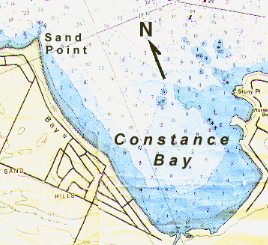
History and an Anchorage at Sand Point
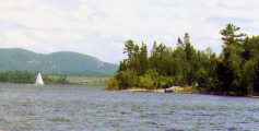
Constance Bay is a prominent feature on this stretch of water.
Sand Point is located in the northwest corner of the bay, and the
area just south of it is a very popular day anchorage for those who like to
stop for a swim. While the point remains a distinguishable landmark on the
river, it is far less impressive than the large sand bluff that used to exist
on this spot during the days when the Ottawa River was the major fur trading
route into North America. Historical notes indicate that by the early 1900's
much of the bluff had been carted away for "building purposes".
Like Aylmer Island, Sand Point has provided evidence of an earlier
Aboriginal presence on the Ottawa River. Human bones have been found in
the sand, and these are believed to be the remains of an Iroquois war party
that suffered a surprise attack by French fur traders along with their
Aboriginal allies (most likely Algonquin and/or Huron).
 The anchorage
is located in the area south of Sand Pt.
The anchorage
is located in the area south of Sand Pt. |
As was the practice in those days, the Iroquois had posted a sentry on the sand
bluff overlooking the
river. However the Iroquois encampment had already been spotted by nearby fur
traders and their Aboriginal allies. Under cover of darkness, they decided to launch
a preemptive strike against the superior and larger Iroquois war party. In the
middle of the night they took to their canoes and quietly landed at the
southern end of Constance Bay. From here the French fur traders and their
allies made their way overland back towards Sand Point. This brought them
behind the Iroquois camp. Their nighttime attack apparently caught the Iroquois
completely off guard.
Although the area south of Sand Point does not offer quite as much
protection from the prevailing west or north-west winds as some other spots
along the river, numerous boats do use it as a fair-weather overnight
anchorage. One of its advantages is that it is relatively free of the hoards of
mosquitoes that plague many other anchorages along this waterway. A gradually
sloping sandy bottom which extends a considerable distance from the beach makes
for easy anchoring. Boats approaching this area should keep an eye out for a
rather long sand bar which jets out under the water from Sand Point.
Buckham's Bay is right next door to Constance Bay, and is a rather odd
formation on the River. It is a long narrow bay - two kilometres long,
but only about 250 metres wide along its entire length (800 feet wide).
Moreover, the west side of this bay is flanked by a fairly steep hill.
Because of its unique shape, it offers good protection from everything
except a northwest wind. While boats do use it as an anchorage (the far
end) when the wind is blowing from a southerly direction, there are
reports that they have to put up with the wake generated by the many
powerboats that zoom in and out of the bay. Some people have suggested
that the number of powerboats in such a confined area means the water
in Buckham's Bay may be a touch less clean than other parts of the river.
Boats heading into Buckhams' Bay should be careful to avoid the shoals
which guard the east side of the entrance to this body of water. And
because of all the powerboat traffic, sailors should make use of a good
anchor light when dropping the hook for the night. Finally, the layout
of this bay mean that it may be difficult to anchor very far from houses
or cottages, and boats may not have very much privacy.
Mohr Island - "a very pleasant island".
 Dropping Anchor at Mohr Island.
 |
Mohr Island is just around the corner from Buckham's Bay. It is regarded by
many as the premier anchorage on this body of water. It offers good
protection from the prevailing winds (from the west to northwest) and it has
a muddy bottom which makes for easy anchoring. The island is strategically located
towards the western end of this part of the river and its anchorage
can accommodate a dozen or more boats.
The anchorage is located in a small bay on the east side of Mohr Island.
While there is usually plenty of room on weekdays, it can become fairly
crowded at the end of the day on busy weekends. However, when the
forecast calls for a relatively light breeze from the direction of the
prevailing winds, a good number of boats can be found anchoring out a
considerable distance from the actual bay at Mohr Island.
 Off
Mohr Island - at dawn.
Off
Mohr Island - at dawn.
These boats are anchored in the
area just east of the bay. |
It is also important to know that Mohr Island can become very crowded
with mosquitoes shortly after sunset. There are few signs of them during
the day, but the minute the sun goes down, insect screens take on a
whole new importance. Some sailors have theorized that Mohr Island is
the breeding ground for half the mosquitoes of North America.
There is a long history to Mohr Island's reputation as a safe and
convenient spot to overnight. Records indicate that Samuel de Champlain
spent a night on the island while exploring the Ottawa
River during his search for the
Northwest Passage. Despite the mosquitoes, Champlain described it as a "very
pleasant island". Royalists among us may be interested to know that, when he
was Prince of Wales, King Edward VII visited a trading post at Crown Point,
just south of Mohr Island on the Ontario side of the river.
Mohr Island is often the turn-around point for people out on a short cruise
and who are anxious to return to their home base on Lake Deschenes. However, the
final ten kilometres (six miles) of the river remaining before the Chats Falls
Hydro Electric Dam has more to offer anyone who cares to push on.
Doing so means passing through the Woolsey Narrows and under high tension wires
suspended high above the river. This is the narrowest part of the Ottawa River
between Lake Deschenes and the Chats Falls Dam, and it is one area where
the current may be noticed, especially in spring or when the dam is spilling
large amounts of water. It is also interesting to note that this part of
the river seems to be a little more remote, and it can give sailors a sense
that they are getting away from cottage country.
 Passing under the high tension wires.
 |
The high tension wires which cross the Woolsey Narrows are supported by
125 foot towers, although it is obvious that the wires sag considerably
lower than this at the mid-point over the river. From an onboard perspective,
a lack of depth perception may give the optical illusion that the boat's
mast will come close to touching these electric power lines. All of this
can be quite entertaining if an unsuspecting passenger is allowed to believe
that the skipper is unsure if there is enough room for the mast to safely
pass under these power lines.
Quyon Revisited
Sailors who cruise beyond Mohr Island know that the small Village of
Quyon is one of the easiest places to put ashore on this part of the Ottawa River.
The approach to the village dock is straight forward, and once tied up, most
everything of significance is an easy 5 to 10 minute walk away.
First time visitors to Quyon should be sure to head for the docks towards
the east (on the right hand side). The structure on the left side serves as the
landing for the local ferryboat. There are no problems when approaching and
tying up to the outside of the cross-dock. However, when the river is low, people
will want to keep an eye out for a few shallow spots if they decide to go on inside
to tie up on one of the three finger docks. (Note that Quyon added the finger
docks a number of years ago for the convenience of transient boaters, but
they may not be installed every year.)
Also noteworthy is the fact that Quyon's waterfront has changed insofar that the
Quyon River (more like a large creek) has found a new opening. It now flows
into the small bay next to the village docks, whereas in the past, its mouth
was a little farther east - closer to the Woolsey Narrows. The result of this
change is that much of the small bay next to the docks has filled up
with sediments flowing from the new mouth of the Quyon River. It's all pretty
easy to see and poses no real problems for boats headed for the Quyon dock. It
is just a matter of being aware that none of this shows up the current edition
of chart #1550.
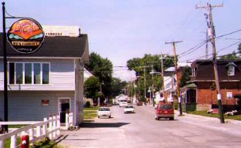 Downtown Quyon.
 |
It is possible to tie up at Quyon for an overnight stay, but be
warned: the locals use the docks as a waterfront playground. It is not
unusual to find kids (and even adults) swimming or fishing off the dock next
to your boat. It may be possible to get used to this, but it is another matter
when it comes to the noise from the local ferryboats. Two boats often operate in
tandem, and their diesel engines make a real racket when approaching or leaving
the ferry landing. Unfortunately, they will be heard operating well past sunset
on busy nights.
In the immediate vicinity of Quyon's dock is a nice park with a good assortment
of play structures for kids. On weekends and many weeks days, a french-fry truck
can often be found nearby doing a brisk business with people waiting to take the ferry.
Sailors experienced with this part of the Ottawa River know that the main
reason for stopping at Quyon is to replenish supplies. A five minute walk
straight up the road to and from the ferry leads to a Stinson gas station which
includes a laundromat and convenience store. At this one location it is possible
to stock up on ice, basic foods, gasoline, diesel, propane, as well as beer, wine,
and hard liquor.
 The Quyon waterfront.
 |
At the Stinson gas station, it is simply a matter of turning right to walk down
Clarendon Street, the main road in Quyon. Within 5 minutes it is possible to
come across a post office, the McCann's Chips (hotdog stand), Lynn's Cafe Restaurant, a Bank of Montreal (may only be opne a few days of the week), the Village Dollar Store, and such landmarks as Gavin's Shamrock Bar.
The cuisine at Lynn's Cafe is okay, but the restaurant does offer a relaxing
terrace for the dining pleasure of it patrons. A Community Health Clinic and
doctor's offices are also within easy walking distance of the docks.
Unfortunately, the Home Hardware Store which had been in business in Quyon for
over 30 years was forced to close in 1997. Moreover, the Marché
McCann, which took over from the bankrupt BoniChoix grocery store, has also closed its doors.
The Chats Falls Dam and power generating station can be seen in the distance from
the Quyon Dock. Although this stretch of water was largely ignored by sailors for
many years, it is one of the more interesting and challenging parts of the
Ottawa River.
It should be noted that versions of chart #1550 dated before 1996 show that the
waters between Quyon and the dam are dotted with cribs that were left over from
the days when the Ottawa River served as a logging river. In reality, these
cribs are no longer there. The Coast Guard had them removed during the summer
of 1993. Apparently, they have been cleared to a depth of approximately two
meters from chart datum, but some people with deep keels remain nervous when
crossing the former location of these cribs. It is interesting to note that
the Coast Guard crews created a new island with all the residual material
from the dismantled cribs (in a shallow area very close to the Quebec
shoreline).
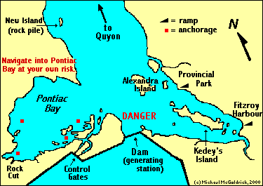
Pontiac Bay will be the destination for most of the boats heading into
this section of the river. The entrance to the bay is located on the
Quebec side of the river just before the dam. When boats get close
enough to see the entrance to the bay in the distance, they will start to head
for the point of land immediately to the west (the right hand side)
of the generating station. They will stay on this heading until they are even with the northern tip of Alexandra Island, and then turn to starboard and head to the approximate centre of Pontiac Bay. People should ready to spot the buoys which mark the entrance to the bay and should proceed with caution - dead slow. Note that these headings
are approximate, and they should be confirmed with the nautical
chart. Moreover, sailors should be keep an eye out for currents
which may develop if the dam is spilling large amounts of water.
Pontiac Bay - a challenging anchorage.
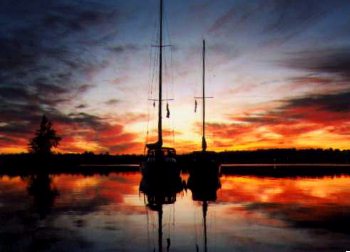 A spectacular sunset in
 |
Pontiac Bay is located on the Quebec side of the river in an area
just west of the Chats Falls Dam, and its various anchorages add a whole
new dimension to cruising on this part of the Ottawa River.
Pontiac Bay is relatively secluded and has the potential to rival Mohr
Island as the premier anchorage on this part of the Ottawa River (and
almost as many mosquitoes). It's numerous anchorages can offer protection
from winds in a variety of directions, and, with the notable exception
of Cadenza Cove, they have mud bottoms. Boats have to use moorings at
Cadenza Cove because the bottom of this anchorage is almost all bare rock.
The south side of Pontiac Bay provides for anchorages which are as isolated and
picturesque as parts of Georgian Bay. Onshore, this area of the bay offers some
great hiking opportunities, especially for anyone interested in climbing the
hill to take a closer look at the dam, dykes, and control gates. (Keep an eye
out for poison ivy when hiking in the wooded areas.)
 The view from the southwest corner of the bay.
 |
In recent years the solitary nature of the area has been affected
by the fact that more boats are finding their way into the bay and by
the operation of a Tim Horton Youth Camp on Pontiac's north-west shoreline.
Despite these developments, the bay still has an abundance of wildlife
and retains its rustic beauty. In fact, it is possible to see deer at
the water's edge in Pontiac Bay early in the morning.
It is unfortunate that a number of under water obstacles make navigating
into Pontiac Bay a chancy proposition. To help overcome this problem, a
loosely knit group of individuals styling themselves as the "Friends of
Pontiac Bay Coterie" have installed private buoys to help mark the
twisting and tortuous channel into the bay. These buoys are BBQ propane
tanks painted green or red, and they may not be visible until one is
almost in the bay (and the red and green paint may be a little faded).
It should also be stressed that several seasons of
winter ice will cause some of these buoys to move from their assigned
locations, although there are periodic efforts to reposition the
wayward markers. (WARNING: Navigating into Pontiac Bay can be difficult, and there are a number of areas where boats can easily go aground and get stuck. Anyone navigating into Pontiac Bay does so
entirely at their own risk.)
[ Click here for more information about
navigating into Pontiac Bay ]
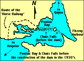
Although Pontiac Bay is difficult to get into, it appears to have been more
navigable in the days before construction of the dam. In the 1800's, steam
boats measuring a hundred feet or more in length would routinely make their
way into the southwest corner of Pontiac Bay to deposit passengers travelling
further up river. Here people would make their way around the Chats Falls on
the "horse railway", which consisted of an open coach pulled by two horses
over approximately three and half miles of track. At the other end of the
railway people boarded another steam boat to continue their journey up the
Ottawa valley.
People may also be interested in going ashore in the southwest corner of
Pontiac Bay to see the rock-cut, the only evidence which remains of an early
effort to construct a canal around the Chats Falls and
 The
Rock-cut - a very short canal.
The
Rock-cut - a very short canal. |
eventually
open up a navigable waterway from the Ottawa River to Georgian Bay.
Work on this rock cut took place between 1854 and 1856 and was
abandoned once people realized that excavation methods of the day
were no match for solid precambrian rock. Almost half a million
dollars was spent excavating a few hundred feet of what was supposed
to be a three mile canal.
Fitzroy Provincial Park (Ontario) is located on the east side of the Chats
Falls Dam. It offers a variety of good quality camp sites and has space
available most of the time. The Park's main beach is located opposite
Kedey's Island, and a smaller children's beach is located in the area
roughly opposite the opening between Kedey's and Alexandra Islands. Park
officials say that it is possible to check into their facility by boat.
However, this option may only be applicable to people in canoes as there
is seldom more than two to three feet of water around the park's dock.
It much the same story for the town dock at Fitzroy Harbour. The area
surrounding the village dock is very shallow and littered with rocks. And despite the
presence of Coast Guard buoys, there is no evidence of a continuous
channel leading to the town on the southwest side of Kedey's Island
(a fact personally verified by the author of this website in a 25 foot
sailboat with a swing keel). It may be hypothetically possible
for a small cruising boat with a retractable keel to reach Fitzroy
Harbour when water levels are unusually high. But generally, this area is
not recommended for anything larger than a small dinghy.
The Chats Falls Dam (and dangerous waters
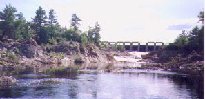 Control gates at the Chats Falls Dam.
 |
Prior to the construction of the dam and power generating station,
the Chats Falls accommodated a 35 foot drop in the river, and consisted
of a series of chutes running from what is now the eastern end of the
dam all the way to the western-most corner of Pontiac Bay. In their
natural state the Chats Falls were quite a tourist attraction. In
the years leading up to World War One it was fairly common to see
large steam boats (paddle wheelers) heading up river with their
decks full of sightseers.
Needless to say, the Chats Falls were obliterated by the dam which
was completed in 1932. The dam's generating station has a capacity
of 224,000 horsepower, and it is interesting to note that the combined
capacity of all the power generating stations along the entire
length of the Ottawa River (including its tributaries) exceeds
4 million horsepower.
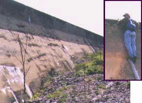 Dyke on the west
side of the Dam.
Dyke on the west
side of the Dam.
Inset: Author of this web site looks on the other side. |
Although not as picturesque as the original falls, the dam and it
facilities are still interesting to visit. Crews of boats anchored
in the southeast corner of Pontiac Bay often climb the hill to get
a first hand look of the control gate, spill ways, and the dykes
on the western side of the dam. However, people using this route
to get to the structure will find that it is a challenge to get a
look on the other side of the dam, as demonstrated by the inset
in photo to the left. (Although it may not be evident from the photo, I
was precariously balanced on top a 10 foot post when I finally
got to look over the dyke.) By going ashore in the southwest
corner of Pontiac Bay (near the rock-cut), it is possible to get
on the dyke. People can then walk along the top of the dyke
towards the control gates for a commanding view overlooking the
Ottawa River below the dam.
The Chats Falls Dam can also pose a danger to boats exploring this end of
the River. Obviously, boats should not go anywhere near the base of the dam in
front of the generating station where there can be severe turbulence and
strong undertows. Generally, boats entering or leaving Pontiac Bay will not
come close enough to the dam to be at serious risk. Nevertheless, very strong
currents can quickly develop
when the control gates are releasing large quantities of water from the reservoir.
The danger appears to be greatest for boats passing in the vicinity south-west
of Alexandra Island. There has been at least one report of a 30 foot sailboat
suffering serious damage when caught by such a current and driven onto rocks on
Alexandra Island.
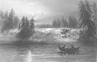 The Chats
Falls - steel engraving by W.H. Bartlett, 1840.
The Chats
Falls - steel engraving by W.H. Bartlett, 1840. |
The dam can also play funny tricks on the water level on this end of the
Ottawa River. Because it is so close, any significant fluctuation in the amount
of water being released by the dam can change the water level by as much as a
12 to 15 inches overnight. The same changes may only translate into a difference
of a couple of inches over a 24 hour period further down river. Anyone navigating
into very thin water to reach a favourite anchorage may want to consider how they
would get out if the water level was to drop a foot overnight.
Obviously, the Chats Falls Dam represents the end of the line
when cruising this stretch of water. From here it is a matter of heading back
to one's home base, which, more often than not, is one the major marinas/yacht
clubs in the eastern end of this part of the river. A return trip between Lake
Deschenes and Pontiac Bay means covering 88 kilometres (54 miles), a distance
that will satisfy most people out on a short cruise.
Text, photos, and maps by Michael McGoldrick.
Web published, 1995.
[ Copyright & Disclaimer ]
[ Return to Home Page ]
[ Sailquest.com ]
|
|